Smiles, Frowns & Misplaced Seafloors: The Case for Accurate Sound Velocity Data
A conversation with industry expert Jonathan Beaudoin

We sat down with Jonathan Beaudoin, a Hydrographic Consultant and self-proclaimed multibeam nerd, to shed light on the critical role of accurate sound velocity data in multibeam survey results. He made one thing very clear: multibeam sonar is the backbone of modern hydrographic surveys, but its accuracy depends on one essential factor — sound velocity (SV).
If multibeam accuracy matters to you (and it should), Jonathan’s Multibeam Crash Course is essential. The insights below are just the tip of the iceberg.
Sound doesn’t travel in a straight line underwater — it bends, or refracts, as it passes through layers of different temperature, salinity, and pressure.

Anything from currents to solar noon to salt domes can dramatically affect these measurements, resulting in vertical layering. In general practice, the top half of the ocean is much more dynamic than the bottom, and conditions may change by the hour. Without accurate SV data, depth measurements can be biased, seafloor positions can be misplaced, and survey results may appear “smiled” or “frowned” when mapped.
Too few profiles may result in biased data: even if it looks clean, everything may be too shallow, too deep, or even a mix of both. Over or underestimating the horizontal and vertical path of the acoustic signal leads to not only compromised survey results but potentially disastrous outcomes, such as seafloor collisions or other navigational risks.
So where exactly does SV come into play?
- At the transducer head: correct surface sound speed ensures that beams are steered at the proper launch angle right from the start. An acoustic pulse is sent from the sensor to a target and back. That travel time is measured and converted into range (depth) using the speed of sound measurement.
- Through the water column: continuous SV profiles account for refraction caused by layering — from surface heating, river outflows, or salinity changes — which strongly affect the path of the acoustic signal. It’s essential that SVPs sample frequently enough to capture a realistic model of the ocean.
What is the impact of incorrect SV data?
Sound speed changing through the water column has two effects: refraction and scaling.

Sound waves refract as they pass through layers of water with different sound speeds (this is Snell’s Law in action). If the profile of the water column isn’t measured accurately, the multibeam sonar system will miscalculate where each beam lands on the seafloor. Consequently, features may appear in the wrong place horizontally — too far left, or too far right — and may have incorrect depths — too deep, or too shallow.
Multibeam sonars record time-of-flight, a.k.a. how long it takes the acoustic pulse to travel down and back. To turn this into depth (distance), time-of-flight is multiplied by the assumed speed of sound. This introduces our second error: if the average sound speed is wrong, then range is scaled incorrectly. The entire seafloor may be shifted deeper or shallower than reality — a vertical error.
Compounded errors
Both of these effects happen at once: refraction distorts where surveyors think the beam landed, and scaling distorts how far it travelled along the ray path. If the SV profile is somehow outdated, too sparse, or miscalibrated, we’ve now got the wrong depth and location. Surveyors often summarize with “garbage in, garbage out”: no amount of post-processing can fully fix a biased dataset.
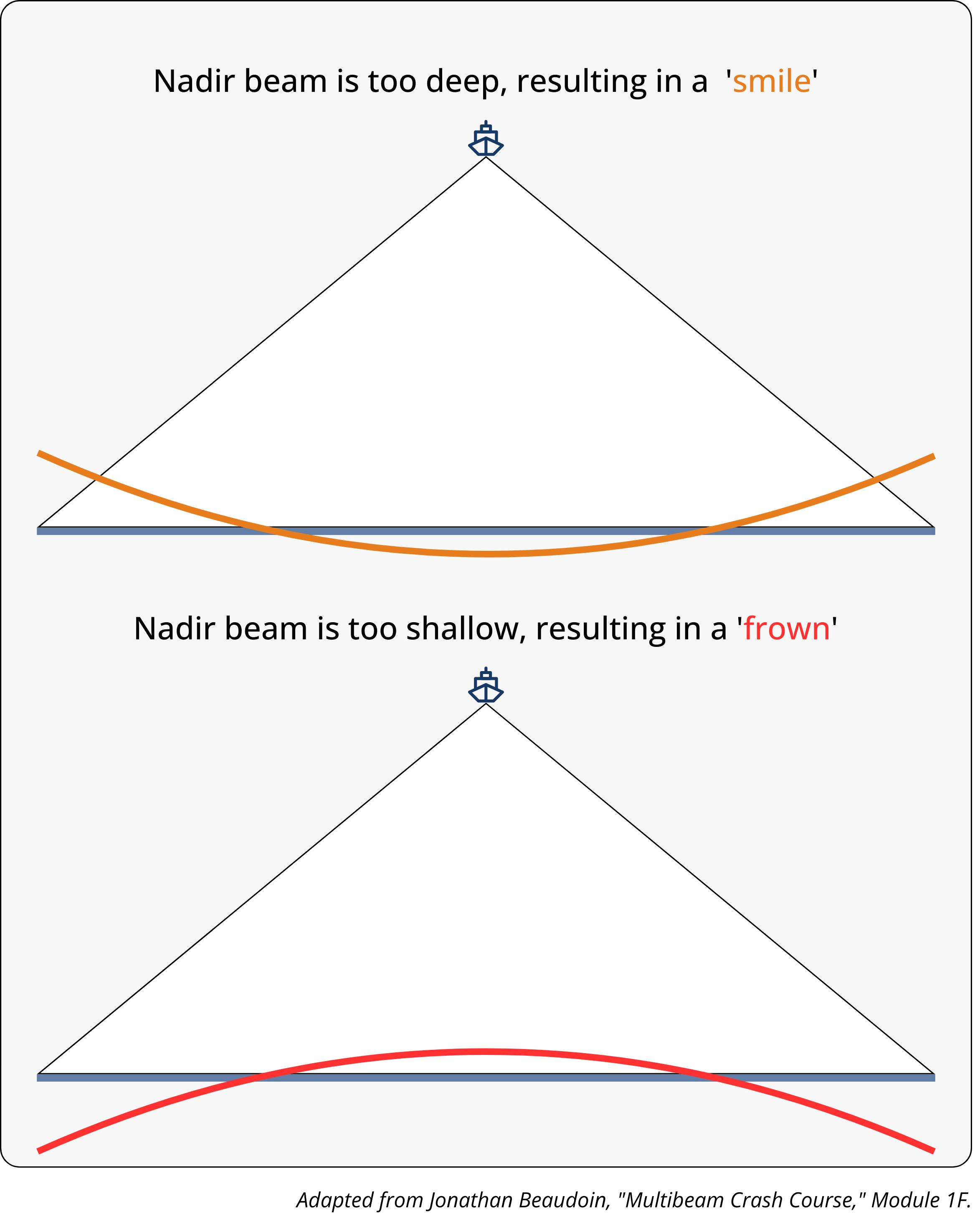
With incorrect SVP, the nadir beam — the sonar beam that points straight down from the transducer to the seafloor — becomes too deep or too shallow. With an inverse relation to the nadir beam, the outer beams will typically arc in the opposite direction. Horizontal distance travelled will also be off due to refraction effects. As a result, we see “smiles” or “frowns” — two classic error patterns in multibeam data, where the seafloor appears to curve up or down at the edges of the swath. These patterns are a big red flag for hydrographers observing their data in real time, and can lead to distorted seafloor maps, safety issues, and costly rework.
The importance of accurate sound velocity data for multibeam surveys cannot be overstated: for hydrographers, it’s the difference between a survey that informs and a survey that misleads.
So… how often do hydrographers need to cast to steer clear of these consequences? That’s a question we’ll tackle in episode two. Stay tuned.
To learn more about Jonathan’s “Multibeam Crash Course”, check out his website https://www.hydrooctave.com/.


.png)


.png)


.png)


